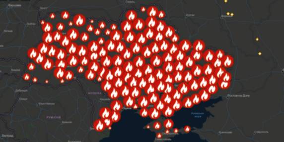
A beta-copy of the all-Ukrainian fire monitoring GIS-map has been created
Kyiv geo-analysts have created a tool to analyse fires in open ecosystems of Ukraine for the last five years, as well as to monitor fires, having broken out for the last two days.
“The all-Ukrainian GIS-map of fires in ecosystems of Ukraine for the last 5 years” has been created by the Centre for Innovation Development in cooperation with Heinrich Boell Foundation, Bureau Kyiv — Ukraine.
According to Vitaliy Selyk, the head of the project of the GIS-map development, while creating the tool, open satellite, governmental and non-governmental data were used (NASA, ESA-European Space Agency, OpenStreetMap, GeoPortalUA, StateGeoCadastre, State Emergency Service of Ukraine).

03 April 2026
Стартував відбір на Резиденцію ідей «Доступно про бюджет: як розвивається громада»
Стартував відбір на Резиденцію ідей «Доступно...
До 13 квітня триває відбір на Резиденцію ідей «Доступно про бюджет: як розвивається громада», яка відбудеться 21–24...
02 April 2026
Громади підключать 100 МВт когенераційних установок за кошти держбюджету
Громади підключать 100 МВт когенераційних...
Громади приєднають до мережі 75 вже наявних когенераційних установок загальною електричною потужністю майже...
02 April 2026
Квітневі каталоги можливостей: підтримка громад та бізнесу
Квітневі каталоги можливостей: підтримка громад...
Великодні свята – час не лише для відпочинку, а й для розвитку. В цьому громадам допоможуть нові Каталоги...
02 April 2026
Громади зможуть отримувати пряме фінансування...
Територіальні громади України незабаром зможуть залучати кошти польського державного банку розвитку BGK безпосередньо...