New territorial administrative division is approaching – some thoughts about situation in the field of spatial planning in Ukraine
Planning of space and of its development, or more often just spatial planning, is one of the most crucial activities in the development of modern society. It goes side by side with strategic planning for communities and countries. And is by that an attempt of society to influence the spatial distribution of people, their activities, and resources. It is a public sector activity and takes place at local, regional, national and international levels. It often results in the creation of a spatial plan in which the tensions among sectoral policies are reconciled[1].
In this paper we would like to make a brief presentation of the situation in the field of spatial planning as well as of the status of preparedness of spatial planning documents in Ukraine. Due to the new territorial division of the country, we will also consider the situation based on the new territorial structure.
Currently, spatial planning in Ukraine is in a transition phase from centralised planning policies and approaches towards modern integrated and strategic approaches. Centralised planning approach in Ukraine was applied in accordance with requirements and policies of economic and state model in Soviet Union resulting mostly in industrial and urban development of cities.
After becoming an independent state and sharp entrance into world market economy, Ukraine has plunged into series of various crises. Development of spatial planning sphere has been put aside from priorities of the state for a long period. In the same time, practical and academical approaches in the field remained very close to the centralised ones, influencing, in their turn, the legislation.
Fortunately, the situation has changed, and the sphere is already among priorities of the Government and MinRegion[2]. It is also seen from the latest developments in adoption of new laws (particularly the law #2280[3]), reformation and opening of State Geocadastre and updating of state’s construction norms (DBN). Actually, before the adoption of the law #2280 the term “spatial planning” wasn’t defined in legislation, instead the term ‘urban development’ was applied for planning of all kind of territories – rural areas, urban areas, rayons, oblasts etc., and spatial plans were called ‘urban development documentation’.
The spatial planning documentation is intended to fix legally the vision of future spatial development/use for certain territory at all levels and scales up to the international one. Here, the main intention is to ensure sustainability and orderliness of the social and economic development, as well as transparency, legitimacy and the same rules for actors. That is why the spatial planning documentation must be publicly available.
Such documentation, if it exists, basically must contain relevant information on current spatial situation (different zones and plots, limitations, infrastructure and networks, population and economic activities distribution etc.) along with the vision and design solutions for future spatial development. In this way, the documentation is the great source for understanding what’s going on in territory, particularly if data comprised there is truthful and adequate to the time.
How the current situation with the spatial planning documentation looks like for whole Ukraine then? Does such documentation exist for each administrative unit and ensure a good basis for sustainable spatial development of Ukraine?
These questions are very relevant also for the U-LEAD with Europe Programme. Namely, the Programme actively supports development of the spatial planning field in Ukraine, particularly at the level of rural municipalities. In the Programme’s portfolio, a Thematic Support Package called “Successful Hromada: Step by Step”. It is designed to support and develop competences of local self-government staff in amalgamated hromadas also in field of ‘Spatial planning and land management’. Here, U-LEAD made a picture of the current state of affairs in the sector in order to ensure delivery of high quality and properly targeted support to Ukrainian communities.
U-LEAD has analysed publicly available data on spatial documentation in Ukraine and developed an Interactive web-map application using GIS technologies. The maps depict answers on two main questions:
- What territorial administrative units possess spatial planning documentation?
- In what year the documentation has been adopted?
The answer on the former question gives an understanding whether any territorial development activities are legal at all, while the latter helps to evaluate the adequacy of the documentation to date, considering the fact that spatial plans have calculation period of 15 – 20 years, which means they should be reviewed and actualized during this cycle.
The analysis is based on data collected on the “PMAP” platform which was created by the Better Regulation Delivery Office (BRDO) with the support of MATRA Programme (The Netherlands) and MinRegion in 2018 - 2019. The project among other was devoted to collecting information regarding availability of urban planning documentation throughout Ukraine. The data is added by local professionals responsible for spatial planning at their level. In general, MinRegion regularly conducts such quantitative monitoring and for 2019 it can be found at MinRegion web-site.
In case of identification of any mistakes or inaccuracies on the maps, please contact a person responsible for spatial planning for the territory you are interested in or visit “PMAP” platform and check how the data can be updated, if you are the person.
Let’s briefly check here, what the analysis has shown, but don’t hesitate to visit the web-map for more information and functionality! There you can find info on each represented administrative unit and even links to published documentation. Meanwhile, below are considered the four administrative levels – national, regional (oblasts), sub-regional (rayons), local (settlements and AHs).
National Level
National level of spatial planning for Ukraine is represented by the General Planning Scheme of the Territory of Ukraine. It was adopted along with a special Law of Ukraine on „The General Planning Scheme of the Territory of Ukraine“ in 2002. It is still valid due infinity of validity terms for urban planning documentation in Ukraine, but a calculation period is coming to the end, so it is a high time for Ukraine to develop a new one especially considering current changes in geopolitical situation.
The General Scheme covers the whole Ukraine and consists of 27 drawings (schemes) and textual materials (‘explanatory note’). The graphical materials are publicly available at the website of the General Scheme’s developer state design institute DIPROMISTO and at the website of the Ministry of Development of Territories and Communities of Ukraine.
Regional level
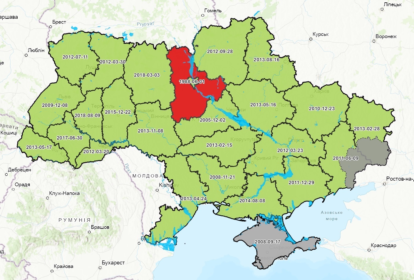
Regional or oblast level (Figure 1. Regional level) is represented by Planning Schemes of Territory of Oblast. According to the data at PMAP resource all oblasts except Kyivska (documentation is dated by 1988) are provided with quite ‘fresh’ Planning Schemes, since most of them were adopted after 2010.
Sub-regional level
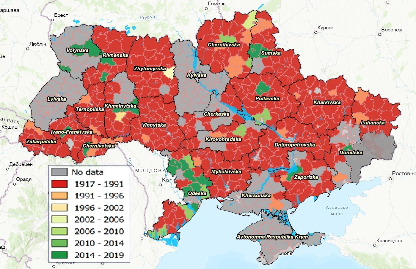
The situation with sub-regional level (rayons) is much worse (Figure 2. Sub-regional level). Data isn’t available for all rayons, but general trend is visible – most of the Planning Schemes of Territory of Rayon were developed and adopted before 1992 – 298 schemes out of 490 rayons in total which gives 61% of inadequate documentation. The percentage is probably even bigger since there is no information on 130 rayons (27%).
Local level – Settlements
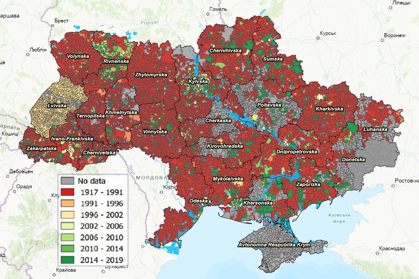
Local level (Figure 3. Local level – Settlements (councils)) is represented by Master plans for settlements (cities, towns, settlements and villages). There is no exact information about 11605 (40%) settlements out of 29726, and 13900 (47%) settlements have master plans dated before 1992. For better visualisation of the data the figure reflects territory of local councils (10375) classified by date of approval of master plan of a main settlement, assuming that the situation with spatial planning documentation is rather similar for smaller and less developed settlements within a given council. There is a separate map depicting each settlement on the web-map.
Local level – Amalgamated Hromadas
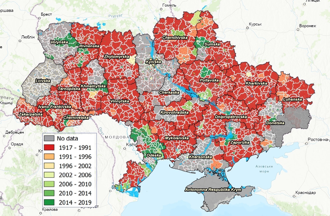
Amalgamated hromadas were in a bit tricky situation until the latest developments in the country (Figure 4. Local level – Amalgamated Hromadas with rayons’ planning schemes as a background). The recent adoption of the perspective plans (1470 AHs) and the abovementioned law #2280, which sets the type of spatial plan for AH’s territory (Comprehensive plan for spatial development of a community), determined the needed basic legal framework. Before it was not 100% clear what AHs should do in this matter, so some of them started development of spatial planning schemes for AH scale as separate document (based on a respective DBN), some as scheme for a rayon/part of a rayon territory. Due to costs, long processes and uncertainty only a handfull of AHs have developed and adopted these documents.
With the mentioned developments, AHs receive opportunities from one point of view and chalenges from the other one. The opportunities are within the powers to manage their territories independently based on the ubiquity principle. The challenges, especially for non-urban AHs, are within the fact that they receive on average 10-20 settlements without an adequate spatial plans along with a need to develop the comprehensive plan for the whole AH. Each AH can check on this map, what it is going to get and where it can find more information/documentation.
Conclusions
It took quite a long time for Ukraine to get to the breaking point in establishing a spatial planning system adequate to the modern needs and challenges. Ukraine stays at this point nowadays and has good perspectives for the future of the field. This is, primarily, thanks to a range of important steps undertaken like reform of decentralisation of powers, preparation towards territorial reform, improvement of legislation (DBNs, law #2280, law on National infrastructure of geospatial data, etc.), reformation of institutions, engagement of wide publicity, etc.
Nevertheless, it is still a lot to be done. On the national level, the most important are: preparation of highly qualified specialists, improvement of legislation, finalization of the reforms, allocation of budgets, creation of a comprehensive spatial (urban) development cadastre, development of the General Scheme of Planning of the Territory of Ukraine and so on. In its turn, local self-governments must create an effective local system of spatial planning management, conduct inventory and systemize data about their territories and assets, establish a sustainable monitoring system and provide its community with transparent and legitimate spatial plans.
The international community actively supports Ukraine in these endeavours by providing experts and financial means. Thus, international projects and institutions provide capacity development measures for stakeholders of all levels. A recent example is by the World Bank, where funds were allocated for supporting the elaboration of 600 spatial development plans for the local level.
The Interactive web-map application developed by U-LEAD with Europe Programme and presented in this article may become an important point of reference for newly formed AHs and international donors in the attempt to understand the situation within each region/AH with availability of spatial plans in order to plan further measures. By rather simple examples, it also demonstrates how useful spatial analysis are and strives to promote establishment of geoportals, especially for the comprehensive spatial development cadastres of national, regional and local levels.
[1] “What is Spatial Planning?”, EU-FAO Improved Global Governance for Hunger Reduction Programme, 2015
[2] See for instance: https://www.kmu.gov.ua/news/oleksij-chernishov-nazvav-golovni-prioriteti-roboti-minregionu-na-2020-rik-ta-zviriv-kurs-z-profilnim-komitetom-vru
[3] Draft Law “On Amendments to the Land Code of Ukraine and other legislative acts on land use planning”, as of 30.06.2020 adopted after the second reading and submitted for signing by the President of Ukraine.
Share the news:


05 July 2024
Впровадження модернізованої версії АІКОМ....
Що потрібно для впровадження модернізованої версії Автоматизованого інформаційного комплексу освітнього менеджменту...
05 July 2024
Якісні державні послуги для кожного: шість громад отримали мобільні ЦНАПи
Якісні державні послуги для кожного: шість...
Європейський Союз та Програма розвитку ООН в Україні в партнерстві з Мінцифрою передали ще для шести громад...
05 July 2024
Реформу профільної середньої освіти обговорили громади Миколаївщини
Реформу профільної середньої освіти обговорили...
У Миколаївській області 28 червня відбулося громадське обговорення цілей реформи профільної середньої освіти. З...
04 July 2024
Курс з проєктного менеджменту від Cities4Cities | United4Ukraine: стартувала реєстрація
Курс з проєктного менеджменту від Cities4Cities...
Спроможність та самозарадність муніципалітетів важлива у контексті відновлення та євроінтеграції. У структурах громад...